Dimension 3D Printer Used as Output Device for Google Earth
Swedish design company constructs Stockholm city model in fraction of normal time.
Latest News
March 1, 2007
By DE Editors
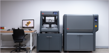
A Swedish design firm hired to create a 157-square-foot 3D model of the city of Stockholm recently completed the project in a fraction of the normal time by using images from Google Earth and a 3D printer from The Dimension 3D Printing Group (Minneapolis, MN), a business unit of Stratasys, Inc. (Eden Prairie, MN).
To construct the Stockholm model, the firm used aerial photos and drawings to create the city’s buildings in a CAD program. When aerial photos and drawings were not available, designers relied on satellite images from Google Earth to prepare these CAD files for the 3D printer. Once printed, the finished building replicas were hand painted along with other landscape features including bridges, cars, boats, trains, and trees.
“A handmade model of this scale would have been a tremendous time investment,” said Martin Jonsson, co-owner and designer at Mitekgruppen, the design firm. “Similar city replicas have taken years to construct. With the Dimension 3D printer and the images we gathered from Google Earth, a project that could have taken years to finish was completed in a matter of months.”
A Swedish daily newspaper reported that the replica was the second most visited exhibit in the country last year.
Images of the Stockholm city model and more information is available at dimensionprinting.com.
Sources: Press materials received from the company and additional information gleaned from the company’s website.
Subscribe to our FREE magazine, FREE email newsletters or both!
Latest News
About the Author
DE’s editors contribute news and new product announcements to Digital Engineering.
Press releases may be sent to them via [email protected].


